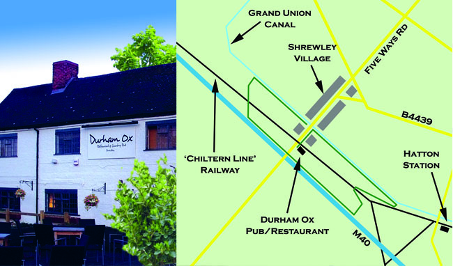
Passing the hamlet of Shrewley are three trunk transport routes from different eras. This is one of those places, like the renowned Watford Gap, where geography forced planners in each generation to choose the same pass through natural features. Our walk takes in all three and it begins at the Durham Ox, ideal for refreshment before or after your stroll.
Walk back a short distance northwards, past the Village Store and a converted chapel, immediately beyond which you can turn right onto a path that leads down to the towpath of the canal, which opened here in 1799.
At that time it was part of the Grand Junction Canal, connecting the Birmingham Navigations, at Digbeth, to Warwick. This became part of the Grand Union in 1929.
A little way down the towpath, a public footpath leads off to the right and then back along the side of the tracks towards a bridge over the former Great Western Railway, the Snow Hill to London Marylebone line, dating from the 1850s.
Beyond the bridge, the path leads on to the side of the M40, carrying traffic here only since 1989.
Bearing right, this path leads along the motorway edge back to and across Five Ways Road in Shrewley and beyond, eventually into woodland, where it cuts back towards another footbridge over the railway.
Following this footpath directly ahead, beyond the bridge, returns you to the canal towpath.Here, turning right, you return to Shrewley. This gains you an excellent view of not only the canal tunnel entrance but also the pedestrian tunnel that leads back up to the village, and to the Durham Ox.
The Shrewley tunnel is 396 metres long, with a width of 4.9 metres, comfortably wide enough for two narrowboats to pass each other.
The route can be a little challenging to follow in a couple of places, particularly on leaving the motorway and railway back towards Shrewley. It is not really possible to get lost, but to sure of staying on track, the best approach is to use Ordnance Survey Landranger Map 151, or the OS Map display option in the Bing Maps app.